838
FXUS65 KTWC 071709
AFDTWC
Area Forecast Discussion
National Weather Service Tucson AZ
1009 AM MST Mon Jul 7 2025
.SYNOPSIS...Expect isolated to scattered storm coverage today
focused on locales generally south and southeast of Tucson. The
main hazard from the storms today will be their capability to
produce strong gusty outflow winds 40-45 mph. The threat of heavy
rainfall will exist near Santa Cruz county this afternoon.
Otherwise, temperatures will be above normal this week with the
potential for extreme heat across Southeast Arizona by the middle
of the week.
&&
.DISCUSSION...The upper pattern today is defined by an elongated
upper high at 500 mb extending across the Southeast Arizona into
central New Mexico with the high center at 300 mb a little farther
south extending from southern Sonora Mexico into the Big Bend
areas of far west Texas. The latest GOES TPW imagery indicted
drier values est of Tucson with PWAT values around an inch across
Cochise and Graham counties, around 1.25 inches near the Tucson
Metro Area with higher values limited to around 1.40-1.50 inches
across the southern Tohono O`odham Nation.
We are expecting a low-grade Monsoon day across the majority of
Southeast Arizona today, with higher more typical Monsoon activity
across Cochise and Santa Cruz counties. The upper high at 500 mb
will be a limiting factor again today as the warm layer will choke
off the majority of deep sustained updrafts. With the high center
positioned near Nogales this afternoon, we see a slightly
diffluent field develop aloft east of Tucson this afternoon. The
thing is is that this area is drier than other areas, increasing
the potential for evaporating downdrafts to accelerate outflows.
In fact, the SPC Mesoscale Analysis this morning indicated DCAPE
values of 1200-1600 J/kg across Graham, southern Greenlee and
Cochise counties this afternoon. The 07/12Z HREF this same area
with a 50-70% neighborhood (40-km) probability for wind gusts
exceeding 30 kts this afternoon SE of Tucson this afternoon, with
even a 10% chance of outflows exceeding 50 kts down in Sonora
where all of the CAMS are indicating a large convective system to
develop early this evening along the SE periphery of the 500 mb
high. As these storms eventually continue to build toward the SW
today toward the deeper moisture that is available, the threat of
heavy rain increases. The 07/12Z HREF indicated a 30% neighborhood
(40 km) probability of exceeding an inch in the 3-hr ensemble
probability matched mean for QPF across Santa Cruz county this
afternoon. Agree with the previous forecast discussion that
mentioned that we will have to watch rainfall totals if storms
move thru Nogales Sonora for possible flash flooding of the
Nogales Wash.
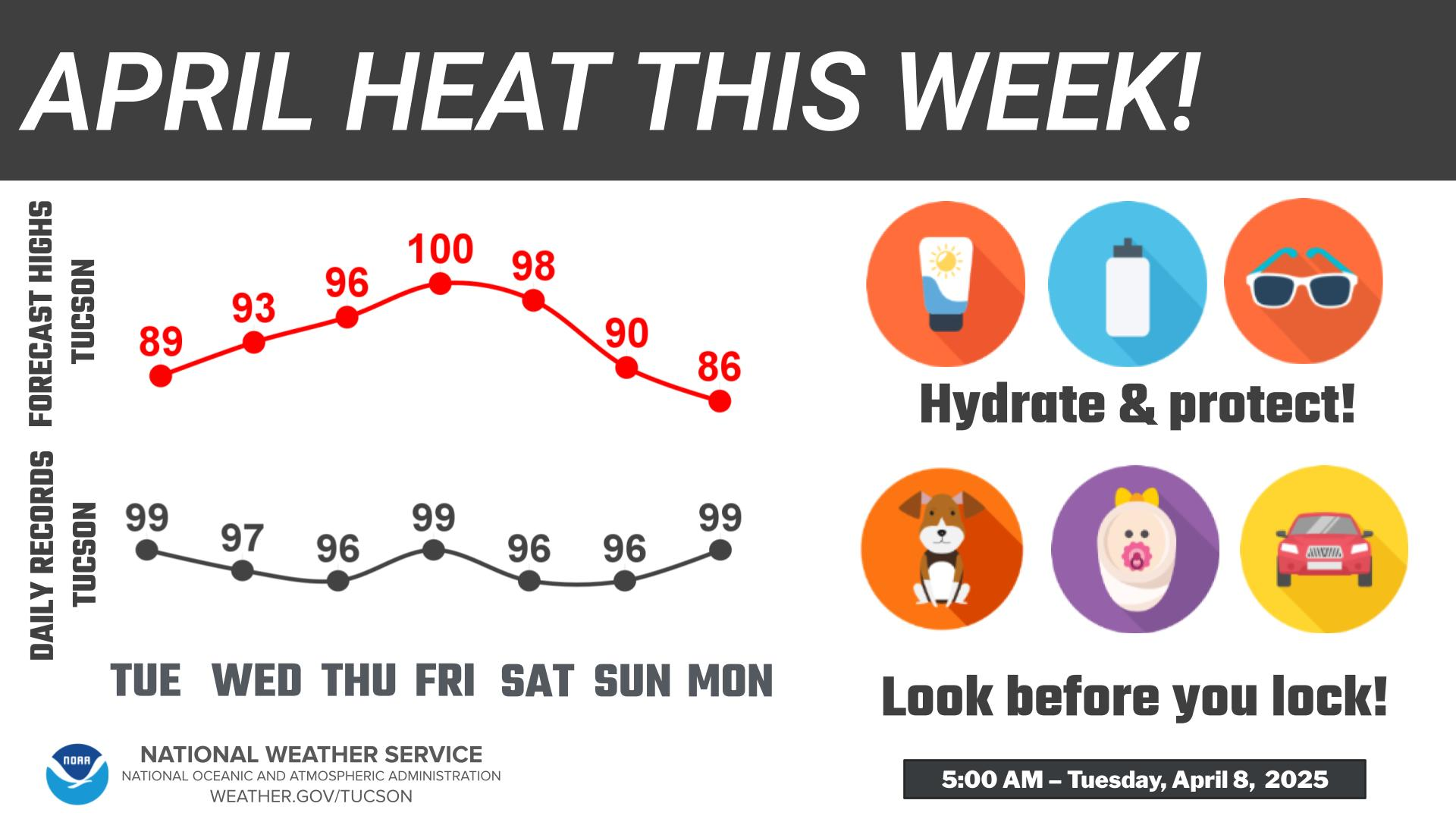
Otherwise, the main weather story this week will be the expanding
strong ridge of high pressure aloft over the state resulting in
very hot, near record high temperatures mid-week with a low grade
Monsoon pattern. The high centers at 300 mb, 500 mb and 700 mb
continue to drift northward, resulting in stacked mid and high
level ridge on Wednesday. As was the case yesterday, there is
still not much variation in 07/14Z NBM ensemble members Wednesday
with only 2 degrees of variation (109-111 degrees) between the
25th-75th percentile at KTUS. The overall probability of exceeding
110 degrees at KTUS is 6% Tuesday, 55% Wednesday and back down to
a 17% Thursday. Confidence is high with the Extreme Heat Warning
in effect for Pima, SE Pinal and Graham counties Wednesday.
We will see the ridge shift the second half of the week into this
weekend resulting in a general uptick in thunderstorm coverage,
especially across the eastern half of our forecast area. The 500
mb high center is progged to shift into southern California by
Friday and even nudge off the southern California Coastline the
first half of next week. This location will allow for a stronger
diffluent upper flow east of Tucson driving storms that develop
in the Whites and along the AZ/NM border in the afternoon SSW
into northern Sonora during the evening. I suspect that large
day-to-day thunderstorm complexes developing in Sonora will
reinforce the surface moisture back into Southeast Arizona behind
organized outflows. The first half of next week looks like an
active high-grade Monsoon pattern as the flow is not only
favorable, but additional deep atmospheric moisture will move its
way northward up the Gulf of California thanks to a nearby tropical
system progged to move NW up along the Mexican coast.
Until then, expect a low-grade Monsoon pattern to persist with
afternoon high-temperatures moving into the very hot/record high
temperature range Wednesday.
&&
.AVIATION...Valid through 08/18Z. SKC to FEW-SCT 12-15k ft AGL
thru 07/18z, then SCT-BKN 7-12k ft AGL with ISOLD-SCT -SHRA/-TSRA
mainly S/SE of KTUS thru 08/04Z with CIGS BKN 5-8k ft AGL and
gusty outflow winds up to 45 kts. Skies will then become SKC-FEW
12-15k ft AGL overnight. SFC winds generally WLY 8-13 kts.
Aviation discussion not updated for TAF amendments.
&&
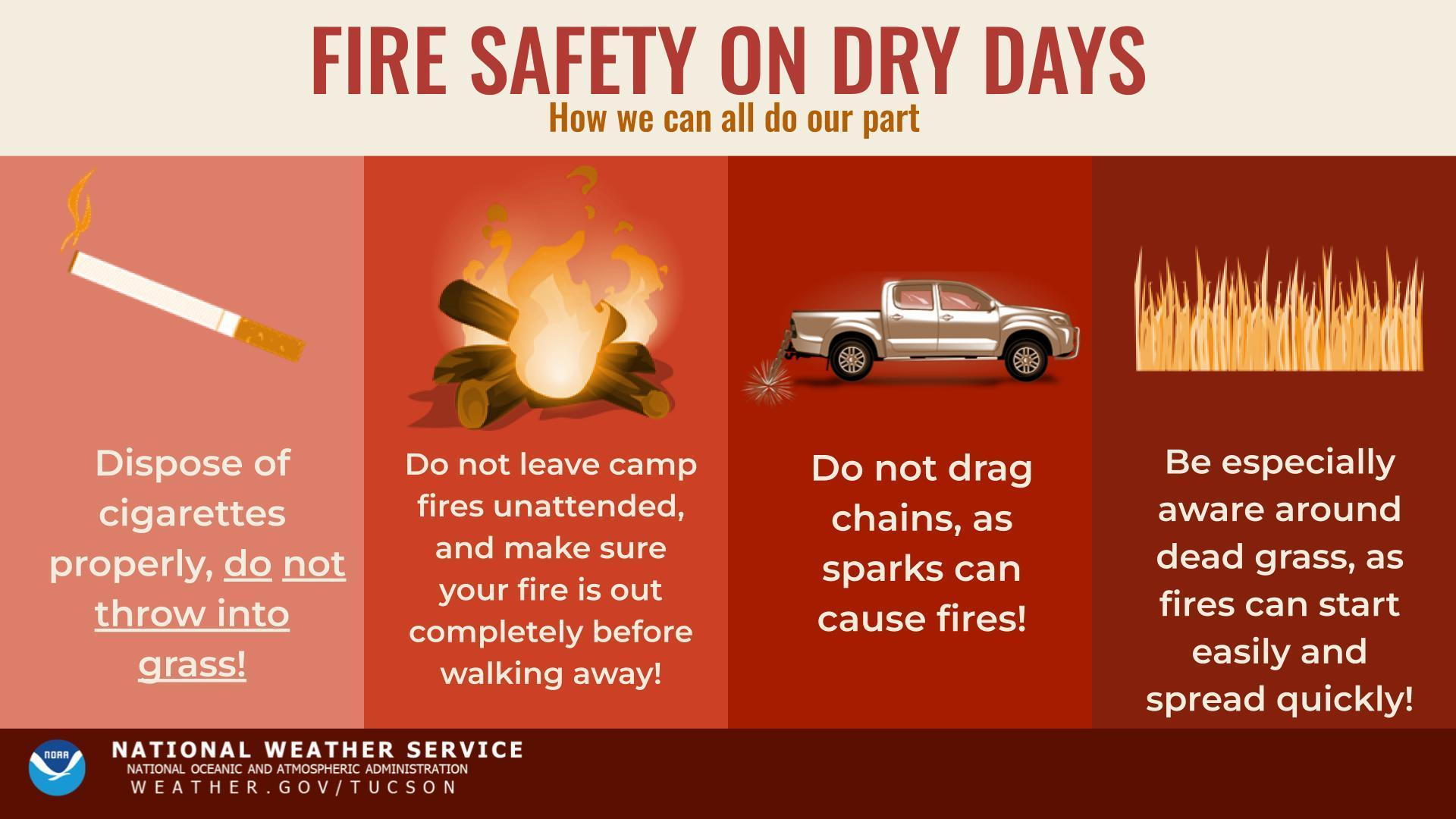
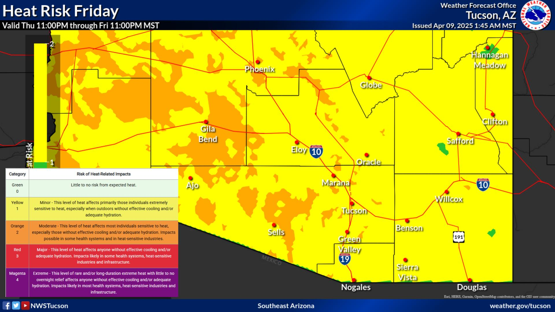
.FIRE WEATHER...Although Southeast Arizona will be experiencing a
low-grade monsoon pattern the first half of the week, isolated to
low-end scattered thunderstorm coverage is expected to the south
and southeast of Tucson for the next several days. The main threat
for storms will be the potential for strong gusty and erratic
outflow winds 40-45 mph. Otherwise, an eventual uptick in monsoon
activity is possible the second half of the week into next
weekend as the upper high shifts to a more favorable location
aloft. Temperatures will be above normal this week with hottest
temperatures mid- week. Winds generally light and under 15 mph
with the exception of gusty and erratic winds up to 35-45 mph near
any thunderstorms.
&&
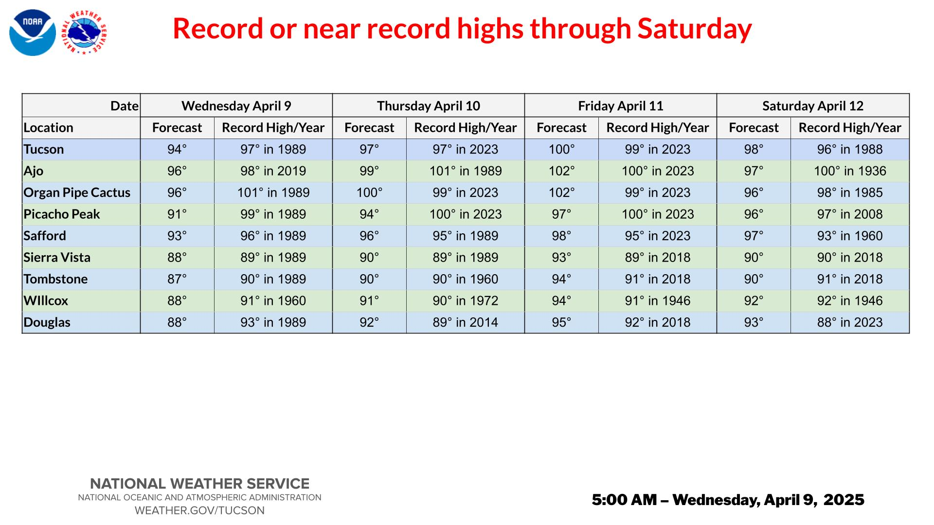
.CLIMATE...RECORD OR NEAR RECORD HIGH TEMPERATURES WEDNESDAY
DATE Jul 09
FCST RCD/YR
TUCSON INTL AIRPORT 110 111/2024
AJO 112 116/2024
ORGAN PIPE CACTUS 111 116/1958
PICACHO PEAK 108 113/1994
SAFFORD AG STATION 110 108/2024
SIERRA VISTA FD 101 104/2024
TOMBSTONE 102 106/1979
WILLCOX 105 109/2003
DOUGLAS 102 108/2003
&&
.TWC WATCHES/WARNINGS/ADVISORIES...
Extreme Heat Warning from 10 AM to 8 PM MST Wednesday for AZZ501-
502-504>506-509.
&&
$$
Visit us on Facebook...Twitter...YouTube...and at weather.gov/Tucson
NWS Tucson (TWC) Office